Nurturing nature
"Local residents are passionate about the natural environment and feel that protecting this is protecting part of their personal identity"
Political voice
We want to protect and expand existing natural habitats and create new spaces for wildlife. We want to ensure that everyone has access greenspace and can benefit from the natural environment.
Set against the backdrop of the Pennine Moors and Peak District parkland, we have some of the UK's most stunning countryside. From the blanket bogs on our moors and ancient woodlands on our steep valleys, to rare flowers such as marsh helleborine on our old industrial sites, Kirklees is rich in nature.
When surrounded with Kirklees' great greenspaces it might be easy to think the nature crisis is restricted to far-off places like the Amazon or Great Barrier Reef. It's not. It's right here on our doorstep. Nature in the UK is in decline, and we are a country that is already one of the most nature depleted in the world. The State of Nature Report 2023 shows that since the 1970s UK species have declined by 19% and nearly 15% of species are currently classified as threatened with extinction.
It's not just nature reserves or protected habitats and species that matter. All greenspaces matter, from gardens to grass verges and parks. Greenspaces and parks make us happier and healthier, so much so that according to research completed by Field In Trust: Revaluing Parks and Green Spaces , across the UK they provide £34.2 billion of wellbeing benefits, reduce heart disease, obesity, and depression - saving the NHS over £111 million per year.
Our natural environment also performs valuable services, like reducing flooding, storing and cleaning our drinking water and absorbing carbon. The Sphagnum moss that grows on Kirklees moorlands can absorb 20 times its weight in water and the Peatlands can contain more than twice the amount of carbon stored in forests.
In everday life, this might look like:
- All residents in Kirklees having access to a rich, thriving natural environment, which improves their physical and mental wellbeing.
- Our buildings and infrastructure enhancing the natural environment they are in, supporting local biodiversity, acting as a catalyst to nature recovery.
- Our industries and communities working together to conserve our natural environment, adding to the value and services it provides so we can continue to benefit from them.
What we have done
Actions to clean up, protect and restore our greenspaces and local wildlife is the focus of many organisations, businesses, and individuals within Kirklees. We have planted 59ha of new trees across the district through community partnerships and volunteers, helping to absorb carbon emissions, bring together communities and restore shared community spaces.
Third sector organisations, such as Natural Kirklees , EPIKS - Environmental Projects in Kirklees and River Holme Connections , work tirelessly to improve our natural environment. From making footpaths more accessible and planting new woodlands, to working in partnership on landscape recovery projects that will deliver benefits to our rural communities by improving soils, increasing biodiversity, enhancing water quality, and reducing flood risk.
Educating individuals on the natural environment has also been a core theme of action. The 'Outdoor Study and Conference Centre' at Cliffe House runs child-centred nature-based educational activities for all, while the third sector organisations such as Support 2 Recovery offer the 'The Great Outdoors Project', working with adults in Kirklees to take their first steps into nature.
Partner case studies
These partner case studies summarise vital action by partnership organisations for the 'Nurturing nature' theme within Kirklees.
MOORLife was an ambitious five-year project, investing €16 million (EU funded) to protect areas of blanket bog. Its conservation work resulted in stabilising and revegetating 52.5ha of bare peat; installing 16,432 mini-dams for re-wetting; planting nearly three million sphagnum plug plants; working with 334 land managers to share best practice; and ultimately protecting 95 sq.km of active blanket bog.
Kirklees Council is a key partner and the accountable body of the White Rose Forest, which has the aim of establishing 2,500ha of new tree canopy cover in our river catchments and 1000ha of new tree canopy in our urban areas and along our major transport routes by 2025. Since declaring a Climate Emergency in 2019, Kirklees Council has created 59ha of new tree canopy cover across the district.
For more information see Woodland creation
What we want to achieve
Nature in recovery by 2030

Resilient futures (RF)
All degraded peatland to be in restoration by 2038

Resilient futures (RF)
Increase Kirklees tree canopy cover to 21% by 2050

Resilient futures (RF)
Environment for all (E4A)
All people who live work and study in Kirklees to have access to high quality green and blue space within 5-10 minutes / 500m walk by 2038

Environment for all (E4A)
'Green and Blue Space' Explained
Green spaces include parks, recreation grounds, public or private gardens, playing fields, play areas, woodland, and other natural areas, grassed areas, cemeteries and allotments, green roofs, and green walls, as well public right of ways (PROWS), such as bridleways, footpaths, canal towpaths and disused railway lines.
Blue space includes canals, rivers, streams, ponds, lakes, and reservoirs.
'High Quality' Explained
Quality of the green and blue space looks at the physical, social, environmental, and visual qualities of the spaces and the value they add to members of the public.
For more information on how this is currently assessed, please look at section 4.3.5 and 4.3.6 in Open Space Study 2015 (revised 2016)
Each objective for 'Nurturing nature' meets one or more of our 'Always On' priorities, Sustainable Economic Development (SED), Resilient Futures (RF), Environment for All (E4A).
Resilient futures
- Prioritising green and blue infrastructure and nature-based solutions in all activities, refurbishments, and developments to restore and improve our natural environment.
Environment for all and Resilient futures
- Conserving, enhancing, and investing in our natural environment and biodiversity, looking at issues like peatland restoration and invasive species management, eradicating pollution, and re-imagining management practices.
- Supporting our Community Forest partnership for the region, White Rose Forest, to plant more trees as part of the wider 50m tree Northern Forest.
Relilient futures and sustainable economic development
- Taking a biodiversity first approach to new development that supports nature recovery and biodiversity net gain.
- Making regenerative agriculture (the conservation and rehabilitation approach to food and farming) a common practice in Kirklees.
Our introduction explains in more detail about our ambitions for this strategy, our always on priorities that each target is underpinned by, and provides more information about each individual target. Alternatively you can download our targets plan on a page graphic.
Summary data for Nurturing nature
Kirklees covers a land area of 40,860ha, of which 11.2% (4,569ha) sits within the Peak District National Park. The 2022 land-use statistics for Kirklees provided by the Department for Levelling Up, Housing and Communities, shows the extent of our existing natural environment, which covers 25.8% of land-area within Kirklees. Importantly, 42.1% of our land is used for agriculture, with outdoor recreational spaces occupying 3.31%.
2022 land-use statistics for Kirklees
Area of land (Ha) by land type
- Forestry and woodland - 3,934ha
- Natural land - 4,002ha
- Rough grassland - 2,599ha
- Agricultural land - 17,208ha
- Outdoor recreation - 1,355ha
- Residential gardens - 4,184ha
% of Total Kirklees Land Area by land type
- Forestry and woodland - 9.6%
- Natural land - 9.8%
- Rough grassland - 6.4%
- Agricultural land - 42.1%
- Outdoor recreation - 3.31%
- Residential gardens - 10.2%
Through the local plan, there is also land designated or protected for biodiversity importance in Kirklees.
In 2022/23 the total land area of biodiversity importance in Kirklees in 6,506ha, which does not include double counted land with more than one designation i.e., ancient woodland that is also a Site of Special Scientific Interest (SSS).
2022 / 23 Land designated or Protected for Biodiversity
2020 to 2023 Area of land (ha)
- Site of Special Scientific Interest - 4,845
- Local wildlife sites - 1,187
- Local geographical sites - 83
- Ancient woodlands - 1,083
- Habitats of principal importance - Not available
A distinct characteristic of Kirklees' natural environment is its rarest habitat - peatland. Inventoried in January 2022 by Moors for the Future Partnership, this ecosystem covers approximately 7,900ha. When in good condition, this provides a huge number of benefits to the district and the people who live, work, study, and visit here - storing carbon; improving water quality; helping to reduce the impacts of flooding; and supporting a rich variety of plants and animals.
Kirklees has 4,230.91ha of deep peat and 3,711.09ha of wet peat. Wet peat is classified as being in good condition, whereas all the deep peats (otherwise known as blanket bogs) are degraded to some degree.
Total amount of peat, by type
Land area (ha)
- Deep peat (over 40cm deep) - 4,230.91
- Wet peat (10 to 39cm deep) - 3,711.09
- Total amount of peatland - 7,942
On the flip side, without the continued protection and restoration of this ecosystem, Kirklees' peatland will generative negative impacts, with the potential to emit ~77,000 tonnes of CO2 per year, which is equivalent to driving a Ford Focus 20 miles every day, every year, for 38,500 years.
Peatlands Explained
Peatland covers around 12% of the UK land area. It is made up of three broad types - Blanket Bog; Raised Bog and Fen. Ultimately peatland is carbon-rich wetlands, made up of peat soil - formed by partially decayed material that is slowly built up, and natural vegetation such as mosses, sedges, and shrubs.
The Peatland factsheet has more information on peatlands and why they are important.
As part of the White Rose Forest initiative, Kirklees has access to BlueSky tree canopy cover data, which provides an understanding of the land area (ha) that has tree canopy cover across the district. As of 2023, Kirklees has 15.17% tree canopy cover.
Current percentage of tree canopy cover
2023 tree canopy cover (ha)
- Total area - 4027.72 ha
- Canopy cover - 6178.75 ha
- Percentage coverage - 15.17%
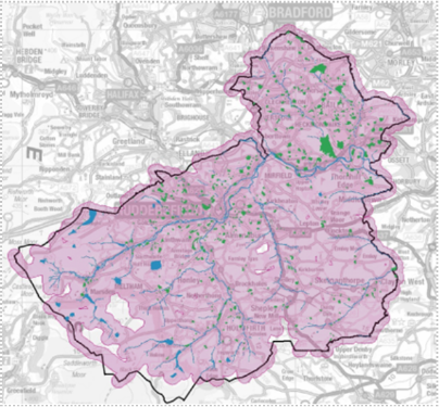
Based on an indicate, high-level analysis undertaken by the Kirklees GIS team, 99.7% of residential properties within Kirklees lie within 500m of green space, blue space, or public rights of way (PROW) within 500m of their homes. A map of Kirklees shows the 500m buffer zone radius, show in purple, which surrounds accessible green and blue space within this zone. This is based on the "OS Public Greenspaces" dataset and the "Water Features Attribute Management" dataset, which may differ from those used in Local Planning policy by Kirklees Council.